Queensland residents draws to the attention of the House the application for Burrum Quarry, Beerburrum-Woodford Road, Beerburrum and the reasons to oppose that application include:
1. Residential homes on Cobb & Co Crescent, Carriage Crescent, Eaton Road and Beerburrum-Woodford Road are only 1.2km from the extension of the proposed quarry site which is only gazetted as a gravel pit.
RESPONSE:
The statement that the quarry site is only gazetted as a gravel pit is untrue.
The Burrum quarry resource is identified as an extractive resource in the Sunshine Coast Regional Planning Scheme and has an extractive resource overly code. One of the purposes of the overlay code is to “protect extractive resource areas and transport routes”.
The Burrum quarry resource is also identified as a Key Resource Area (KRA) in the State Planning Policy. KRA’s are “identified as containing important extractive resources of state or regional significance which the state considers worthy of protection for future use.”
There are 12 residential houses on the west side of Cobb & Co Crescent and 1 rural house on the north side of Eaton Road that will be approximately 1.7km away from where the quarrying will recommence. Over the next 10 to 20 years quarrying will move progressively eastwards but will never become closer than 1.2 kms away from these houses.
2. Noise impact from blasting, crushing machinery with 150 truck movements daily through Beerburrum Township and Glasshouse District affecting schools, retirement villages, tourism, agri-business and existing infrastructure.
RESPONSE:
MWA Environmental consultants assessed the potential noise impacts from quarrying activities which included conducting existing background noise monitoring and preparing a detailed noise generation model.
The conclusion of the assessment was that the proposed quarrying activities can comply with the regulatory noise limits at the closest house with the implementation of noise control measures.
Those control measure have been adopted into the Site Management Plan and it is expected that SCRC would condition any approval such that it is mandatory for Barro Group to comply with the Site Management Plan.
It is important to understand that much of the Beerburrum township is already subject to existing high noise overlay areas.
The Sunshine Coast Planning Scheme Beerburrum Local Plan Area shows that properties covered by the solid grey shading “Major Road Corridor and Buffer” will be subject to high road noise levels.

The properties covered by the green hatched shading “Railway Corridor and Buffer” are also subject to high noise levels related to the train line, especially from the diesel powered locomotives, and it was a SCRC condition of approval for many of the properties in the Acacia Grove housing precinct that the when the land was sold, potential buyers must be provided with an acoustic report detailing the extent of the railway noise and that covenants must be registered against the titles for road traffic noise affected lots.
The section of Beerburrum Road through the town is identified in the Sunshine Coast Regional Council (SCRC) planning scheme and in particular in the Beerburrum Local Plan Area. The Local Plan clearly recognises this section of road as being a “Major Road Corridor and Buffer” and its intended use is for a high volume of cars and trucks.
To understand the impact of the quarry trucks on Beerburrum Road through the town it is helpful that the SCRC requested that Barro Group engage a traffic survey and engineering company to conduct physical counts of the current vehicle quantities which has allowed an analysis to be undertaken to determine what the real impact of the quarry trucks would be.
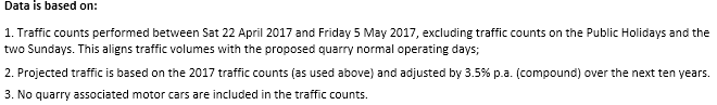
Current traffic volumes on Beerburrum Rd through the township without the quarry are on average 4838 vehicles per day including 176 trucks.
With the addition of the quarry trucks the results are best demonstrated in the pie charts below and it is very clear that the overall impact of the quarry trucks will be very low.
TRAFFIC PROJECTIONS PER DAY
BEERBURRUM RD (through town) – QUARRY HEAVY VEHICLE (HV)

There is clear intent in the SCRC planning scheme and the State’s designations that Beerburrum Road has an intended use for high traffic volumes and heavy vehicles and the data shown in the pie charts confirms that the heavy vehicles associated with the quarry extension will have minimal impact to the on the Beerburrum township.
3. Beerburrum Mountain is part of the heritage listed Glasshouse Mountains area, an important link to our nation’s history as part of the Mathew Flinders Heritage Trial, and must be protected from destruction.
RESPONSE:
The inference that Burrum Quarry in some way will be responsible for the destruction of Mt Beerburrum is untrue.
There should be no confusion that the Burrum Quarry site is in the middle of a commercial pine plantation and is not within the Burrum Mountain State Forrest which is some distance away.
4. Road infrastructure, including a small railway bridge, is suffering greatly and is the only northern access to Beerburrum for vehicles, pedestrians and emergency vehicles.
RESPONSE:
This statement is untrue.
The owner of the bridge, the Department of Transport and Main Roads (TMR) have advised:
TMR Ref: TMR17-020371
SARA Ref: SDA-1216-035995
With respect to the concerns regarding the Beerburrum Road Bridge over the rail line, I note the following:
- The bridge has previously been assessed for heavy vehicle loading and upgraded, and is considered appropriate to handle these types of loads. While the bridge appears to be an older style timber bridge, it is considered capable of handling heavy loads.
- The traffic generated by the quarry is mostly considered to be part of “general traffic” in terms of heavy vehicle regulation, while some b-double generation for the quarry operates under permit. Given the suitability of the route, these permits are anticipated to continue.
- The route is recognised as an approved b-double route through historical usage/demand.
- The road geometry and widths through this bridge are recognised as being ‘tight’, however, again given the historical heavy vehicle use for local quarry, forestry and farming operations, along with the route being an approved b-double route, TMR considers the use of the bridge appropriate to continue given there are no other logical alternate routes to the highway in this area.
5. No benefit to the Beerburrum Community regarding jobs as workers are on contract with Barro Group P/L.
RESPONSE:
This statement is untrue.
Barro Group do not have any contract arrangements relating to employment at Beerburrum, we don’t have an operating business there currently. We have had many calls from people seeking employment but we have no ability to provide new employment opportunities unless the Burrum Quarry Extension is approved.
If Burrum Quarry Extension is approved, local people and local suppliers will be given preference.
6. HQ Plantations Pty Ltd currently lease the surrounding pine forest. They’ve advised they will harvest trees which will remove the current sound barrier between the houses and the proposed quarry extension.
RESPONSE:
Barro Group advised the participants at the public meeting on 20 July that HQ Plantations had provided information that the planned harvest time for the pine plantation surrounding the quarry was 2025.
The meeting was also advised that irrespective of this that a stand of 20m high remnant vegetation barrier would remain almost completely surrounding the quarry.
A power point presentation was shown to the attendees demonstrating where the 20m high stand of remnant vegetation is and the same information was also contained in the visual amenity report that was provided as part of the application documents supplied to SCRC.
7. Beerburrum State School would face hazard and safety issues from 150 truck movements daily.
RESPONSE:
Beerburrum State School will face no hazard and safety issues from 150 truck movement daily however it is the safe movement of children arriving and departing from the school that is of interest to Barro Group.
Beerburrum State School is a small school with about 160 students which is accessed from Beerburrum Rd at the township.
Currently without the quarry operating, on average a total of 4838 vehicles, including 176 trucks, travel past the school each day along Beerburrum Rd through the township. It is expected that if the quarry is approved, on average, an additional 7 quarry trucks travelling in both directions will pass the school in the hour that children will be arriving and in the hour that children will be departing the school.
Whilst the additional quarry trucks will only increase the current traffic by about 3% Barro Group engaged traffic engineers to study the current infrastructure that is in place around the school to assist with providing a safe environment for the children when arriving and departing from the school.
The report has been provided as part of the documents supplied to SCRC and is available for viewing by any interested party.
The key finding of the report are that all the required infrastructure is already in place, which is not surprising given the already high traffic volumes passing the school.
- Off street one way children drop of area
- Off street long term day car parking
- Diamond school crossing ahead warning signs both ways
- Solar powered illuminated flashing school zone signs operating from 7am to 9am and 2pm to 4pm limiting the speed to 40km/hr
- Well identified and marked school crossing zone including flags that is controlled by an authorised crossing Supervisor
- Long sight distances in both directions enabling plenty of visual warning time for slowing and stopping
- The bus bay is indented from the main carriage way
A recent inquiry was been made in regard to truck braking time and Barro Group commissioned a traffic engineer to provide information on this matter.
The report has been supplied to SCRC and concludes:
“The available sight distances and therefore the associated truck stopping distances are more than sufficient”
As an additional management initiative, Barro Group intend to implement a driver’s code of conduct which has been provided as part of the application documents supplied to SCRC.
8. The proposed quarry site is located within traditional lands of the Jimbara and Gubbi Gubbi people. There has been no consultation with these groups.
RESPONSE:
This statement is untrue.
The quarry is located on Part Lot 589 on FTY 1876. This land is recognised on the Register of Native Title Claims QUD280/2013 as land associated with the Kabi Kabi First Nation (pronounced as Gubbi Gubbi).
Amongst the 7 named applicants for this claim is Bianca Beetson. Barro Group contacted Kabi Kabi First Nation and their contact people Bianca Beetson and Tony Dalton nominated cultural heritage services company Archaeo to act as their technical advisors including accompanying Kabi Kabi representatives on a site survey.
A Cultural Heritage Assessment report was prepared and submitted to SCRC by Barro Group as part of the Development Application documents.
Whilst is well acknowledged that the Jinibara People have a Native Title Determination QUD6128/1998 which covers a large area of land in the Sunshine Coast region, the Determination does not cover the quarry location Part Lot 589 on FTY 1876.